Fact Sheet
BACKGROUND and CURRENT STATUS
Beginning in January 2011, hydrocarbon sheen was observed during low tides in the Dominguez Channel about 400 feet south of the Carson Street Bridge. The Los Angeles Regional Water Control Board (LARWQCB) has been working in collaboration with various federal, state and local agencies to facilitate the environmental assessment and remedy of the release. In July 2011, under the direction of the LARWQCB, Resource Environmental LLC (RELLC), an industry environmental management firm, began its assessment. It initiated an interim remedial program in August 2011. Since 2012, RELLC has assumed full environmental management on behalf of the potentially responsible parties and continues to work closely with the LARWQCB. It has adequately completed assessment of the project area and is currently progressing towards appropriate remedial action for the channel and adjacent areas. RELLC also strives to work with the community and in particular City of Carson officials. It’s had an open dialogue with officials and seeks to keep the public informed though the city officials, a project public website, and occasionally through direct contact to the public.
With the exception of a minor sheening event from July 10 to 14, 2013, and sheening events in March 2019, April 2020, March 2023, and February 2024, no sheens have been observed in the channel since 2012 as the interim remedial measures have been effective and significantly reduced the presence of sheen. The many booms used to contain and capture any sheen that traversed the channel were removed in March 2013, then re-installed in March 2019, April 2020, March 2023, and February 2024. Absorbent material is also used continuously in the side drains within the channel levee in the vicinity of the sheening. In addition, four wells (R-MW-6, R-MW-11, R-MW-12, and R-MW-15) located on the west side of the channel have been used to recover product under the western portion of the channel levee where sheening had been previously observed. These wells remain operational even though product is now infrequently recovered.
ENVIRONMENTAL INVESTIGATION RESULTS
Results of these investigations since July 2011 have determined that the observed sheening is most likely from pipeline release(s) from the 1950-80 era. The sheening appears to be primarily entering into the water from the horizontal perforated sub-drain pipe systems installed within the western levee and secondarily from the sediments within the bottom of the channel. The sheen material has been identified as cracked naphtha mixed with a small portion of southern California crude. Cracked naphtha is most commonly used as the primary material to make gasoline.
In general, the areas impacted by historical pipeline leak(s) have now been identified. To date, RELLC has installed a significant number of borings within and outside the channel and also monitors a large network of groundwater wells that provides a reasonable understanding of the environmental condition in the project area and how these areas were impacted.
The most likely scenario is that the leak(s) occurred at a time when the regional groundwater table was substantially deeper than its current levels. Over-pumping of the Los Angeles groundwater basin in the 1940s into the 1970s led to large declines in regional groundwater levels and facilitated saltwater intrusion into the basin. During this time, the suspected product release(s), unaffected by groundwater, most likely migrated downward to approximately 30-35 feet below the ground and just under the channel. Since the early 1970s, saltwater intrusion has been mitigated by several fresh water injection projects including Los Angeles County Department of Public Works’ Dominguez Gap Barrier Project. Imported and reclaimed water was injected into a deep aquifer just 2 – 4 miles south of Dominguez Channel where this assessment is focused. As a result, groundwater levels gradually recovered and eventually rose to the base of the Dominguez Channel in the 1990s to 2000s, bringing the released pipeline material upward. By 2011, a limited area of the sediment of the channel became saturated with the material released from the pipeline(s) and migrated to the perforated side drains of the levee.
FUTURE PLANS
To prevent sheening, RELLC will continue to use absorbent material in the side drains of the channel levee in the vicinity where historical sheening has occurred. Four product recovery wells (R-MW-6, R-MW-11, R-MW-12, and R-MW-15) located on the west side of the channel will remain operational. If sheening is observed in the channel, absorbent booms will be used to contain the sheen.
Groundwater monitoring of the well network (69 wells) will be conducted on a semi-annual basis. Assessment of the Project Area has been completed. The storm drains on E. Carson Street have been sealed to mitigate an odorous vapor issue within utility boxes/vaults located near the intersection of S. Perry and E. Carson Streets (May/June 2017).
A long-term remedial program will be developed. It is currently on hold pending the outcome of the LA County potential widening project (2030?).
TIMELINE
- Installation of booms across the channel as necessary
- Recovery of product from side drains of the channel levee and the four product recovery wells (ongoing)
- Semi-annual groundwater monitoring and sampling from 69 wells (ongoing)
- Development of a long-term remedial program (schedule to be determined)
For general information about RELLC, go to www.rellc.net. For general information regarding the “Dominguez Channel LNAPL Investigation” in Carson, California, go to www.dominguezchannel.com
CONTACT INFORMATION
If you would like additional information about the environmental assessment, please contact:
Los Angeles Regional Water Quality Control Board
Majd Nima, Project Manager
320 West Fourth Street, Suite 200
Los Angeles, CA 90013
213-576-6707
Majd.Nima@waterboards.ca.gov
City of Carson
Christopher Palmer, Planning Manager
701 East Carson Street
Carson, CA 90745
310-952-1761
CPalmer@carsonca.gov
RELLC
Greg Vogelpohl, Vice President & General Manager
310-857-2334 (Local)
800-461-9960 (Toll Free)
Dominguez-info@rellc.net
SITE SPECIFIC DETAILS
Channel and Levees:
- Installed groundwater monitoring wells (2011-2017); conducting groundwater sampling that confirms that contaminant concentrations and areas of contamination are stable or decreasing (2011-2024)
- Conducted soil sampling at the channel and along levees to identify contamination (2011-2017); identified specific areas with LNAPL; pumping out LNAPL that might otherwise get into channel (2011-2024)
- Conducted studies that showed that pressure from rising groundwater levels sometimes forces some contaminants up from the base of the channel into the water, which occasionally causes a sheen (2015 – 2024)
- Deploying absorbent booms on the channel (as needed) to contain and remove sheen (2011-2013, 2019-2021; 2023; 2024)
- Removing LNAPL from levee subdrain system to prevent it from getting into channel (2011-2024)
Former Active RV Property (1202 East Carson Street):
- Conducted soil and soil vapor sampling (2011-2012; 2023-2024)
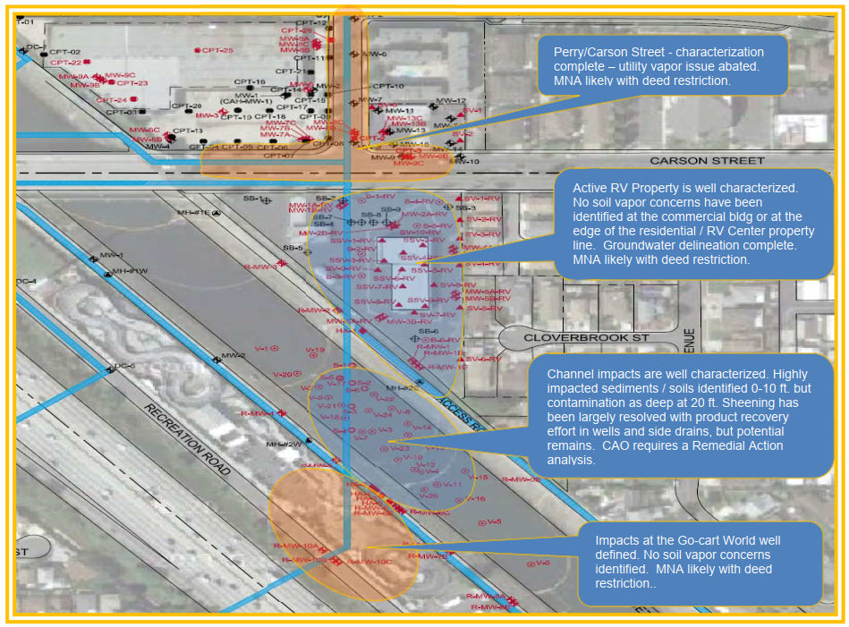
- Investigation on east side of site showed there are no known impacted soils and no known vapor intrusion issues at the eastern boundaries adjacent to the residential neighborhood
- Evaluation of impacted soils near and under commercial building on-site pose no vapor concerns to current property commercial use. Long-term restrictions likely needed with a deed restriction to limit future property for commercial use.
- Installed groundwater monitoring wells (2011-2012); conducting groundwater sampling that confirms that contaminant concentrations and areas of contamination are stable or decreasing (2011-2024)
Neighborhood Adjacent to Active RV (Ashmill Street, Cloverbrook Street):
- Installed borings and groundwater monitoring wells (2014; 2024); conducting groundwater sampling that shows that very few contaminants are detected, and concentrations of any detected contaminants are very low (2014-2024)
Former Carson Air Harbor Facility (21611 Perry Street);
- The LARWQCB identified this site as a potential source of contamination to the Dominquez Channel
- However, 2011 investigations showed the site was not a source of contamination to Dominquez Channel
76 Station #6082 (1025 East Carson Street):
- The LARWQCB identified this site as a potential source of contamination to the Dominquez Channel
- However, 2011 investigations showed the site was not a source of contamination to Dominquez Channel
Former Texaco Station (1209 East Carson Street):
- The LARWQCB identified this site as a potential source of contamination to the Dominquez Channel
- However, 2011 investigations showed the site was not a source of contamination to the Dominquez Channel, and the LARWQCB granted environmental case closure for this site in 2015