Phase 1: July – September 2011
– Installed and sampled six groundwater monitoring wells in the access roads along the eastern and western sides of the channel
– Drilled 12 shallow soil borings within the channel bed and collected soil, sediment, and petroleum samples
– Installed absorbent materials along channel levee sub-drain manholes near the area where petroleum sheen had been observed, conducted weekly inspections and replaced absorbent material as necessary, and removed petroleum daily from monitoring Well R-MW-6, where liquid petroleum accumulates.
– Chemically analyzed sediment, soil, groundwater, petroleum, and saturated absorbent material samples
– Conducted an outdoor air assessment
Summary of Results: Petroleum seeping into the channel appears to be a refined oil product (a cracked
naphtha) from one or more pipeline sources. Specific pipeline source(s) are unknown. Results from the
outdoor air assessment did not reveal a health risk from the odor of a sheen that was observed partially
covering the channel.
Phase 2: October 2011 – February 2012
– Installed and sampled nine additional groundwater monitoring wells in the access roads along the eastern and western sides of the channel and three wells within Recreation Road
– Drilled 20 additional shallow soil borings within the channel bed and collected soil and petroleum samples
– Chemically analyzed soil, groundwater, and petroleum samples
– Conducted removal of petroleum from groundwater monitoring Well R-MW-6 in the western levee access road
– Continued weekly inspections and replacement of absorbent material in the channel levee sub-drain manholes, and removed petroleum daily from monitoring Well R-MW-6, where liquid petroleum accumulates
Summary of Results: The extent of recoverable petroleum appears to be limited to the immediate area
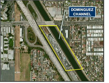
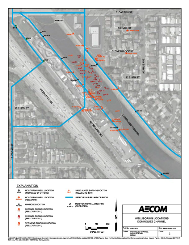
of the channel in the vicinity of a pipeline corridor that crosses the channel and along the western levee at Well R-MW-6, which is approximately 950 feet south of E. Carson Street. Investigative work performed along the eastern levee and the former Active RV site has not revealed a similar release point of petroleum contribution east of the channel. An Interim Remedial Action Plan (IRAP) was prepared to prevent degradation of the surface waters of the Dominguez Channel while a more permanent remedy is developed and implemented.
Phase 3: October 2013 – 2014
– Conduct GeoTrax Survey™ screening across the channel, along the western channel levee, within Carson Street and Recreation Road, and at adjacent properties (GeoTrax Survey™ is a non-invasive tool that allows one to better understand soil and groundwater impacts along the survey lines)
– Install additional petroleum recovery wells along the western channel levee
– Conduct exploratory trenching along the pipeline corridor within the western channel levee
– Continue weekly inspections and replacement of absorbent material in the channel levee sub-drain
manholes, and removal of petroleum from monitoring Well R-MW-6, where liquid petroleum accumulates
Summary of Results: The type and limited extent of LNAPL detected beneath the Dominguez Channel has been identified. Although a specific source may not have been identified, the most likely release(s) was from a local product pipeline(s) that is no longer active or present. The results to date indicate that the larger source areas exist along the western levee. Ongoing investigations have only detected limited, isolated release points of non-recoverable LNAPL outside of this area.
The conclusions based on results of the assessments conducted to date are as follows:
– LNAPL is present beneath the Dominguez Channel approximately 400 feet south of the Carson Street
Bridge. The extent of recoverable LNAPL however is limited to the immediate area of the channel south
of a pipeline corridor that crosses the channel and along the western levee.
– The LNAPL source material beneath the channel can be described as a naphtha-range refinery
intermediate, or a form of “cracked naphtha”, combined with a low percentage of crude oil from either separate crude oil release(s), prior pipeline use for crude oil, or as a minor fraction of the original naphtha-range material.
– There were no evident age-specific chemical indicators in the LNAPL that would help in age dating.
– Crude oil is found at slightly higher percentages in the samples collected from the former Active RV site and E. Carson Street than in the LNAPL samples collected along the western levee, which have higher naphtha-range refinery intermediate percentages, indicating that the crude oil components are coming more from the northern than the southern portion of the Project Area.
– The LNAPL has been detected with elevated concentrations in soil and groundwater primarily along pipeline corridors, which is a likely indicator that the LNAPL source(s) is one or more pipelines.
– None of the active pipelines within the Project Area reportedly either carry, or have historically carried, a naphtha-range product similar to what has been detected in the channel. Therefore, the likely source(s) of LNAPL beneath the channel is from the historic release of a currently inactive/idle or abandoned pipeline(s). However, since pipelines have existed in this area since the 1920s, the former operations of inactive/idle or abandoned pipelines could not be fully determined due to limited historical records.
– One location that is a likely source area of LNAPL to the channel is along the western levee. Soil samples collected in this area are heavily impacted from about 5 feet bgs (approximately 23 to 25 feet above the base of the channel) to 50 feet bgs (20 feet below the base of the channel and 15 feet into the B Zone).
– Historically low water tables followed by increasing groundwater levels due to reinjection associated
with the Dominguez Gap Barrier Project could have created a condition where LNAPL migrated below
the channel base into permeable soil (B Zone) and then became trapped beneath low-permeable silts
and clays as the groundwater table rose. As hydrostatic pressures increased in the mid-2000s, the LNAPL was then forced into shallower soils, eventually migrating into the levee drainage piping, and then through the side-drains into the channel. Similar pressure increases would have caused some LNAPL to migrate through the channel base, appearing as small pockets of sheen on the channel surface. Between data showing that these pressures and the associated increase in groundwater elevations have recently stabilized and the interim remedial actions taken (i.e., adsorbent socks in the drains and product recovery wells on the western levee), the immediate issues associated with the presence of LNAPL around the channel have been resolved.
– Investigative work performed along the eastern levee, E. Carson and S. Perry Streets, Recreation Road, and the former Active RV site have only detected limited, isolated points of LNAPL that are similar to the channel LNAPL, but non-recoverable.
– Impacts from operations at the former CAH, former Texaco, and 76 sites are not related to LNAPL detected in the Dominguez Channel.
– Potential environmental receptors include the open water body of the Dominguez Channel, surrounding neighborhoods that might be potentially affected by volatilization of LNAPL sheen causing a nuisance odor, and commercial/residential receptors from vapor intrusion to indoor air. In part, due to interim mitigation efforts being performed in the Project Area, there is no apparent immediate threat to environmental receptors.
Phase 4: December 2023 – January 2024
-Installed two groundwater monitoring wells in the southern portion of Recreation Road and collected and analyzed soil and groundwater samples.
Ongoing
– Weekly inspection of the channel levee sub-drain manholes for petroleum sheen, replacement of
manhole absorbent socks as necessary, and daily removal of petroleum that accumulates in wells along the western levee. If sheening is observed in the channel, absorbent booms will be used to contain the sheen.
– Semi-annual groundwater monitoring.